Shiningintl full frequency navigation decoy module is a system spoofer module based on navigation signal decoy, it covers all navigation system of the world, and it can be used everywhere of the world.
Product Description
Introduction to the Module
Shiningintl Navigation Satellite Decoy Full Frequency Module (also called satellite navigation spoofer system )is the only full-band wireless module for anti-UAV field on the market, which covers all frequency band signals of global GPS, BDS, GLONASS, Galileo, QZSS and IRNSS navigation satellite systems. Intelligent replacement of navigation information as set deception data to achieve the purpose of controlling UAVs is the most technical, covert and effective way among all anti-UAV equipment. The module can be widely applied to anti-UAV scenarios worldwide, and the device is compact, light, simple and easy to use, has comprehensive functions and reliable performance, and is convenient for users to integrate quickly. Based on the advanced navigation satellite signal simulation technology, the module broadcasts the deception simulation satellite signal consistent with the navigation satellite signal by accurately simulating the on-orbit navigation satellite signal. After the UAV receives the analog satellite signal sent by the equipment, it uses the analog satellite signal to locate and output the corresponding position.
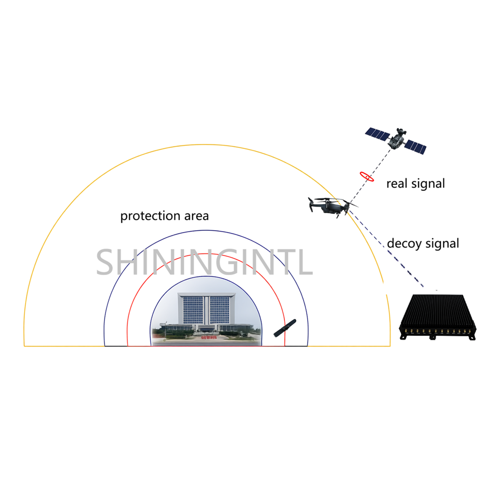
The above schematic diagram shows the schematic diagram of Shiningintl navigation satellite decoy system. After obtaining the local navigation information signal, the module will process the information and inject the decoy information into the simulated navigation information, which skillfully covers the original navigation information. The UAV equipment can not distinguish the true and false information and can only work under the navigation information.
Deception Method:
Various decoy modes for the unmanned aerial vehicle can be realized, including course guidance, expulsion, forced landing, rapid crash, and the like;
Specific Functions
- Full function module to realize navigation system signal receiving and transmitting on one module
- Wide coverage, single module to achieve global coverage, can be applied anywhere in the world, single module supports any frequency band of BDS, GPS, GALILEO, GLONASS, QZSS, IRNSS
- It can carry out navigation decoy for UAV relying on satellite navigation and positioning system, and realize UAV forced landing, course guidance, prohibition of take-off, navigation satellite signal interference and other objectives.
- Support the external DF module to identify the target azimuth, and use the course guidance function to control the horizontal forward, backward, left and right movement of the target UAV.
- Support external command to control arbitrary navigation signal combination transmission;
- Support external commands to set any position coordinates (longitude, latitude, altitude), or built-in fixed coordinates;
- Support external instructions to set signal delay, motion speed, acceleration and other simulation parameters;
- Support external commands to set preset tracks such as linear motion and circular motion;
- Supporting external filling motion track, the module calculates and outputs the corresponding navigation satellite signal according to the input information;
- Support real-time ephemeris mode and permanent ephemeris mode;
- Support the setting of preset coordinates for power-on automatic transmission;
- Support satellite navigation signal suppression jamming output;
- Provide control interface for secondary development of network;
arameters
- Covering a specific channel
Support GPS, BDS, GLONASS, Galileo, QZSS and IRNSS navigation satellite signal simulation, and the signal output frequency band and channel number are as follows.
Signal frequency band and frequency table of decoy satellite navigation system
| System | Signal frequency band | Center frequency (MHz) | Channel number |
| BDS | B1I | 1561.098 | 1 |
| B1C | 1575.42 | 2 | |
| B2I | 1207.14 | 3 | |
| B2a | 1176.45 | 4 | |
| B2b | 1207.14 | 5 | |
| B3I | 1268.52 | 6 | |
| GPS | L1 C/A | 1575.42 | 7 |
| L1C | 1575.42 | 8 | |
| L2 | 1227.60 | 9 | |
| L5 | 1176.45 | 10 | |
| GALILEO | E1B | 1575.42 | 11 |
| E1C | 1575.42 | 12 | |
| E5a | 1176.45 | 13 | |
| E5b | 1207.14 | 14 | |
| E6C | 1278.75 | 15 | |
| GLONASS | L1 (G1) | 1602 + k×0.5625 | 16 |
| L2 (G2) | 1246 + k×0.4375 | 17 | |
| L3 (G3) | 1202.025 | 18 | |
| QZSS | L1C/A | 1575.42 | 19 |
| L1C | 1575.42 | 20 | |
| L5 | 1176.45 | 21 | |
| IRNSS | L5 | 1176.45 | 22 |
- Parameter
Maximum transmitting power: ≥ 10dBm;
Power adjustment range: 80dB, minimum resolution: 1dB
Power-on startup time: 60 s;
Navigation satellite signal synchronization time: < 180s;
Power sourc:
Input voltage: DC 20 ~ 28V
Power consumption: ≤ 40 W.
Working temperature: -40 ℃ ~ + 50 ℃
Storage temperature: -40 ℃ ~ + 80 ℃
Weight: < 2.0 kg
- Interface
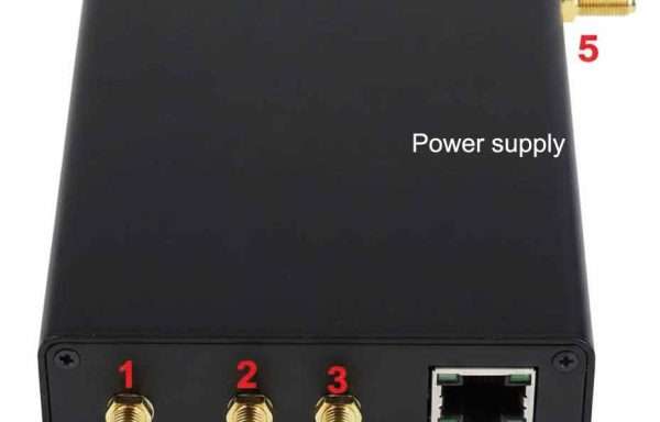
Module interface definition:
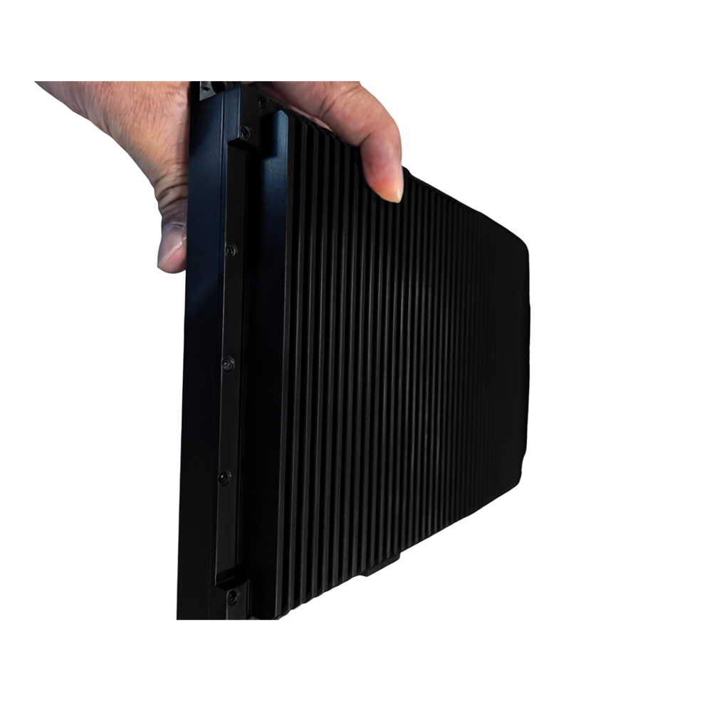
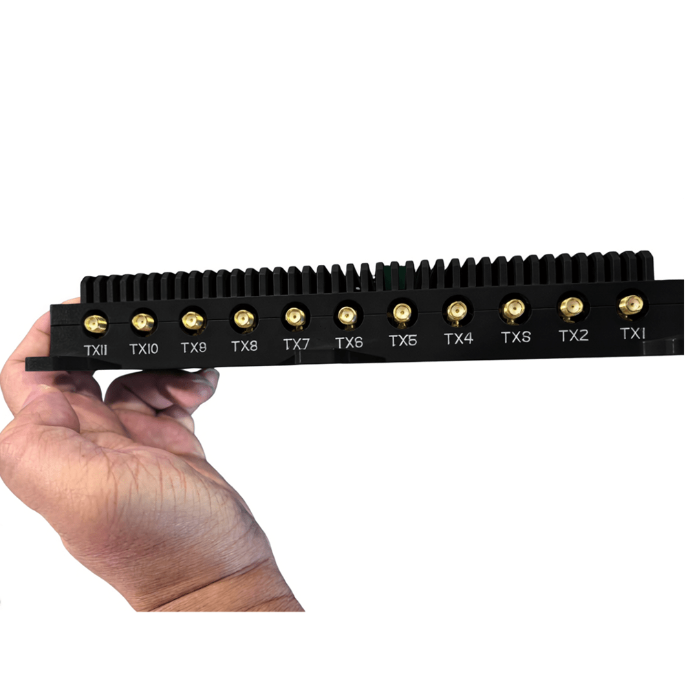
Signal receiving port: SMA, 1 channel, receiving navigation satellite signal, supporting DC + 5V feed;
Signal transmission port: SMA, 11 channels, transmitting navigation satellite signals;
Power input interface: XH2.5-2P male socket, 2-way
Network port communication interface: RJ45, 1-way, SFP, 1-way
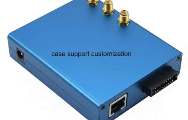
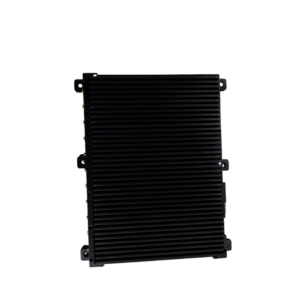
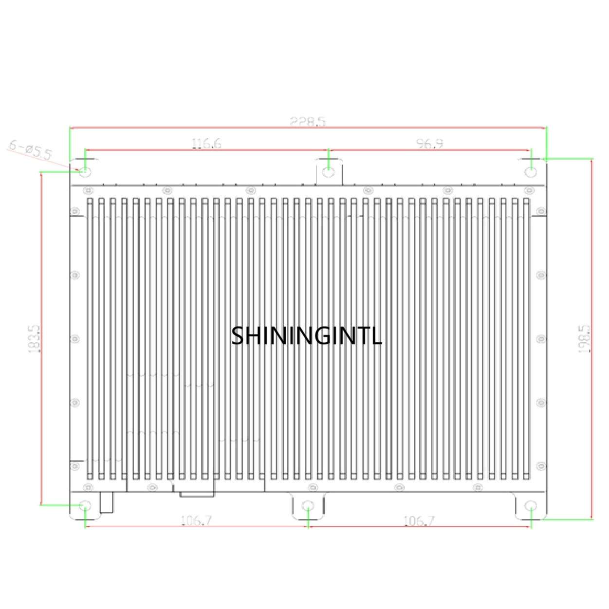
- Physical dimensions,
Product size (without connectors): 228.5mm (L) × 198.5mm (W) Support shell customization, if need special case to fix your structure design, please contact us for case modification.
Operation
We have the configuration software for this module, the setup details please follow the Shiningintl Navigation Deception
Equipment SH-USP-01 User Manual, the manual will show detail configuration steps . Before the the software operation, please make sure all the hardware components are installed correctly, include the power supply, receiver antenna, emission antenna, cable to connect between the navigation decoy module and computer.
Accessories
This full frequency navigation decoy module uses 1 antenna go receive real time navigation signal from field, this signal works for all navigation system including GPS, BDS, GLONASS, Galileo, QZSS and IRNSS,