Shiningintl Navigation Satellite 4 Band Spoofer Deception C-UAV Four-Frequency Board

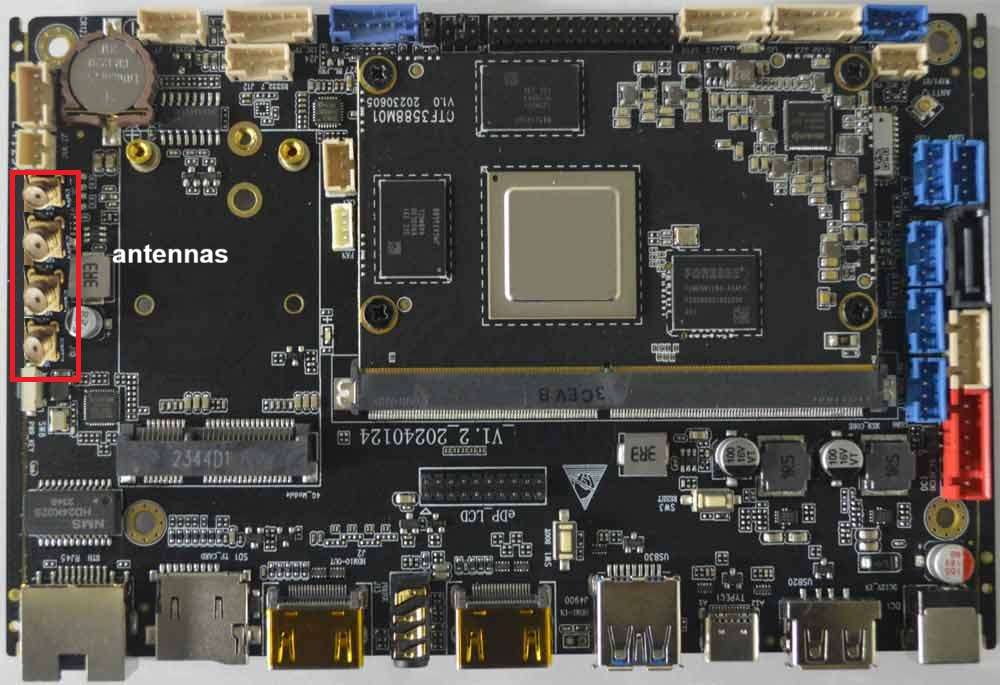
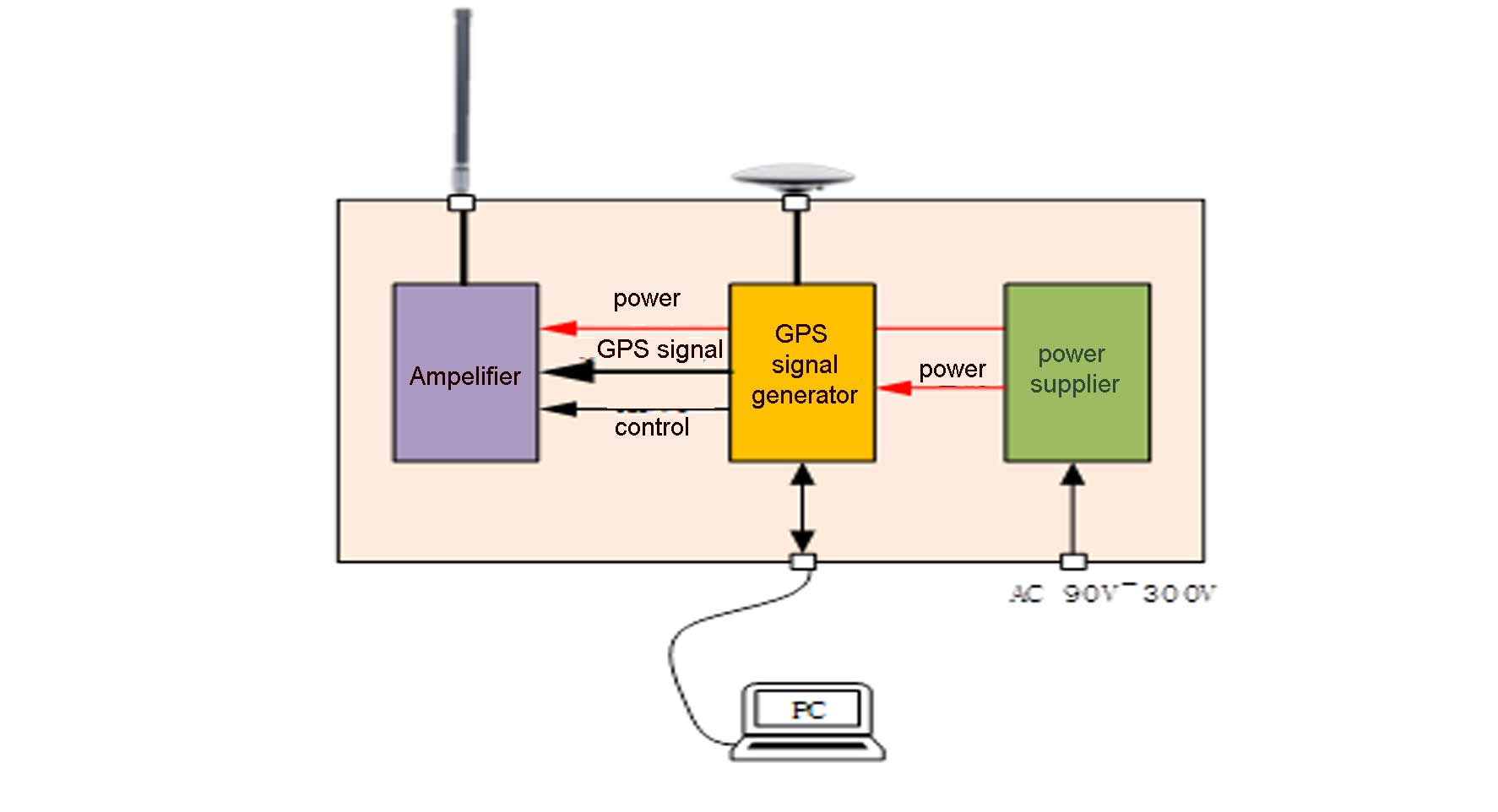
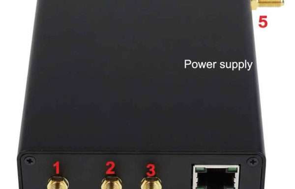
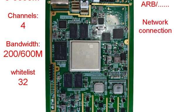
The Shiningintl Navigation Satellite GNSS spoofer 4 bands Board is a compact, high-performance anti-drone module designed for critical infrastructure and security applications, including oil & gas, power, public safety, and defense. Leveraging advanced navigation satellite signal simulation, the board generates authentic-looking GPS, BeiDou, GLONASS, and Galileo signals across four frequency bands (BDS-B1I, GPS-L1, GLONASS-L1, Galileo-E1), each with 16 channels. By emitting precisely controlled spoofing signals that override genuine GNSS signals, it effectively deceives drone navigation systems—enabling course deviation, forced landing, takeoff prevention, expulsion, or emergency crash scenarios. The module supports dynamic parameter adjustment (e.g., signal delay, speed, acceleration), preset or externally injected trajectories (linear, circular), and real-time or permanent ephemeris modes. It features external control via RS422 serial and Ethernet interfaces, compatibility with direction-finding modules, and automatic coordinate transmission on startup. With a transmit power of ≥−10 dBm and 80 dB adjustable range (1 dB steps), it ensures flexible and stealthy operation. The board operates in temperatures from −40°C to +60°C, weighs under 150 g, and consumes ≤9 W from a 10–28 V DC supply. Designed for seamless integration into existing counter-UAV systems, it offers reliable, multi-mode GNSS-based drone mitigation with minimal electromagnetic footprint.

Product Description

System architecturer:

shiningintl navigation GPS deception anti-drone C-UAV system board

Product Features

  1. Supports signal reception and simulated transmission for common frequency points of the four major global navigation satellite systems.
  2. Deceives drones reliant on satellite navigation systems to achieve objectives such as forced landing, course deviation, takeoff prevention, and signal interference.
  3. Supports external direction-finding modules to identify target orientation and control horizontal movement (forward, backward, left, right) via course deviation.
  4. Allows external command control for arbitrary navigation signal combinations.
  5. Enables external command configuration of arbitrary coordinates (longitude, latitude, altitude) or preset fixed coordinates.
  6. Adjusts simulated parameters (signal delay, motion speed, acceleration) via external commands.
  7. Supports preset trajectories (linear, circular) and external trajectory injection for dynamic signal output.
  8. Operates in real-time ephemeris mode or permanent ephemeris mode.
  9. Auto-transmits preset coordinates upon power-up.
  10. Provides satellite navigation signal suppression and jamming output.
  11. Offers secondary development interfaces: serial (RS422) and Ethernet (RJ45).

Key Technical Specifications

Technical Parameters

  • Supported Systems & Frequencies:
No. Satellite System Frequency Band Channels
1 BDS B1I 16
2 GPS L1 C/A 16
3 GLONASS L1 16
4 Galileo E1 16
  • Signal Reception Frequencies: BDS-B1, GPS-L1, GLONASS-L1, Galileo-E1.
  • Max Transmission Power: ≥-10dBm.
  • Power Adjustment Range: 80dB (1dB resolution).
  • Startup Time: 40s.
  • Signal Synchronization Time: <180s.

Physical Dimensions & Interfaces      

  • Dimensions (excluding connectors): 120mm (L) × 100mm (W).
  • Weight: <150g.
  • Power:
    • Input Voltage: DC 10–28V.
    • Power Consumption: ≤9W.
  • Interfaces:
    • Signal Input: SMA port (supports DC +5V feed).
    • Signal Output: SMA port.
    • Power Input: XH2.5-2P male connector.
    • Serial Communication: HC-ZH-4PWT (RS422).
    • Ethernet: RJ45.

Operating Environment

  • Operating Temperature: -40℃ to +60℃.
  • Storage Temperature: -40℃ to +80℃.